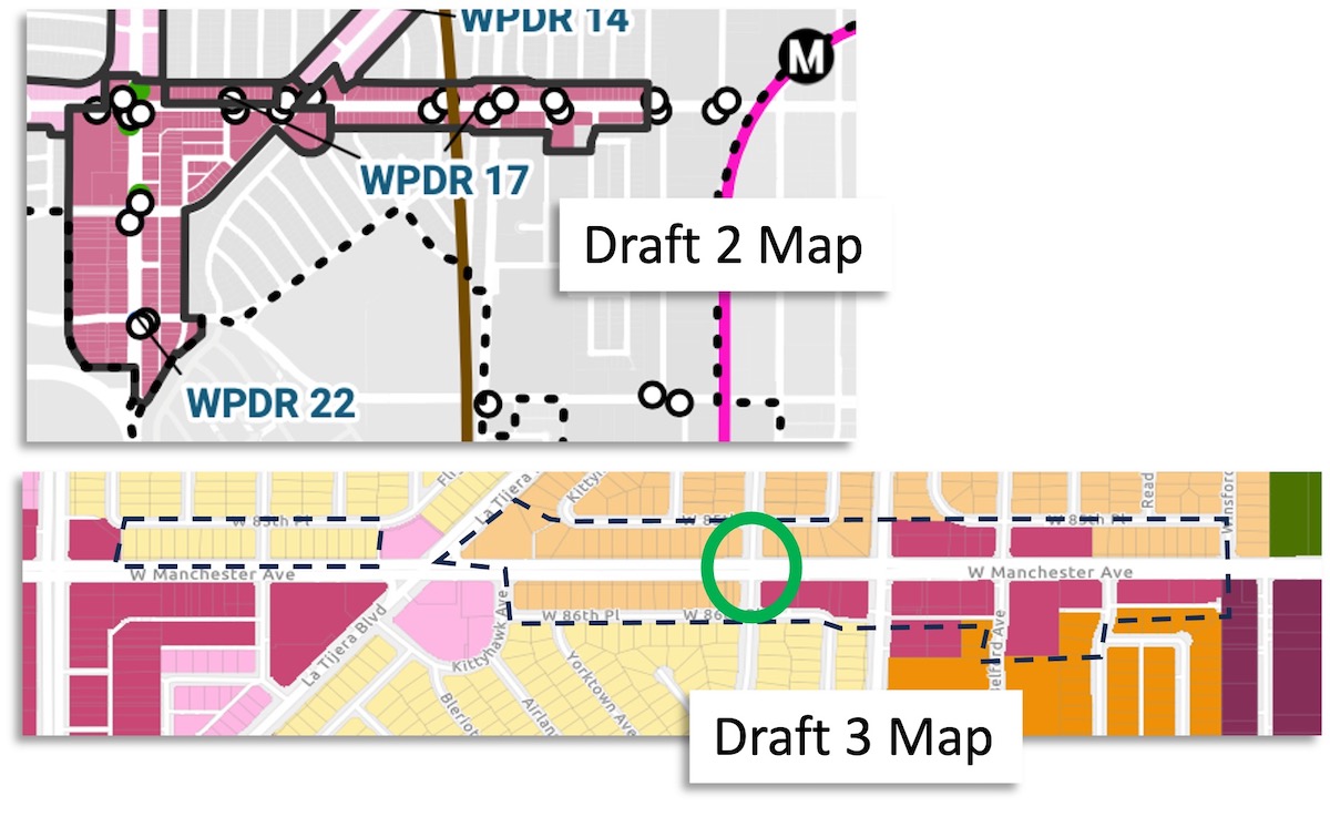
Draft 3 Map Recap / WPDR 17 – Manchester between La Tijera and Winsford Ave)
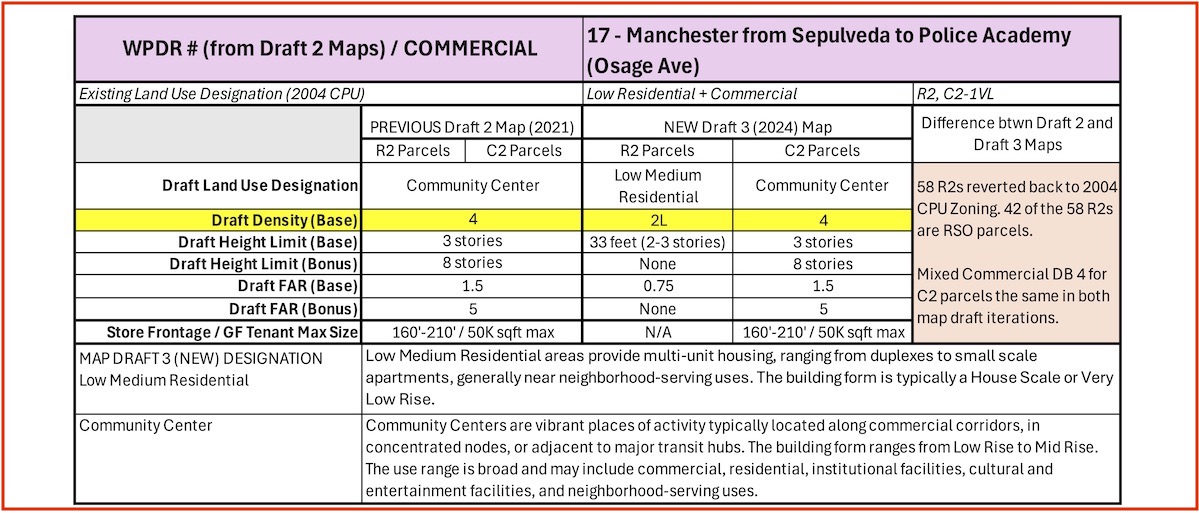
- Change for R2 parcels only: Lowered Land Use Category and Density Base
- No Change for DB 4 Commercial parcels.
- Land Use Category
- Community Center = vibrant places of activity typically along commercial corridors, in concentrated nodes. Building from ranges from Low Rise to Mid Rise. Use is commercial, residential, institutional, entertainment, neighborhood-serving uses. Residential density: 1 unit per 800 sq ft of lot area to 1 unit per 200 sq ft of lost area. (Per LA General Plan definition.)
- Low-Medium Residential = Low Medium Residential areas provide multi-unit housing, ranging from duplexes to small scale apartments, generally near neighborhood-serving uses. The building form ranges from House Scale to Very Low Rise. The residential density generally ranges from 1 unit per 3,000 square feet of lot area to 1 unit per 1,000 square feet of lot area.
- Residential Building Size Density Base 2L
- Height Limit (Base) = 33′ (2-3 stories)
- Height Limit (Bonus) = none
- Floor Area Ratio (FAR / Base) = 0.75:1
- Floor Area Ration (FAR / Bonus = none
Our Concern
Given WPDR 17 is in a good location for residential access to the Metro station, we feel some portion of parcels on Manchester should be considered for up-zoning, bringing more housing to the TOC area.
We agree with the Draft 3 Map proposal of DB4 Mixed-Use Commercial in this area. But worry about lack of policy or supportive incentives to keep small business owners returning to future new buildings.
Our Map Change Recommendations
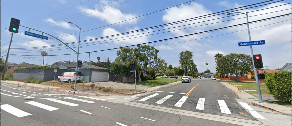
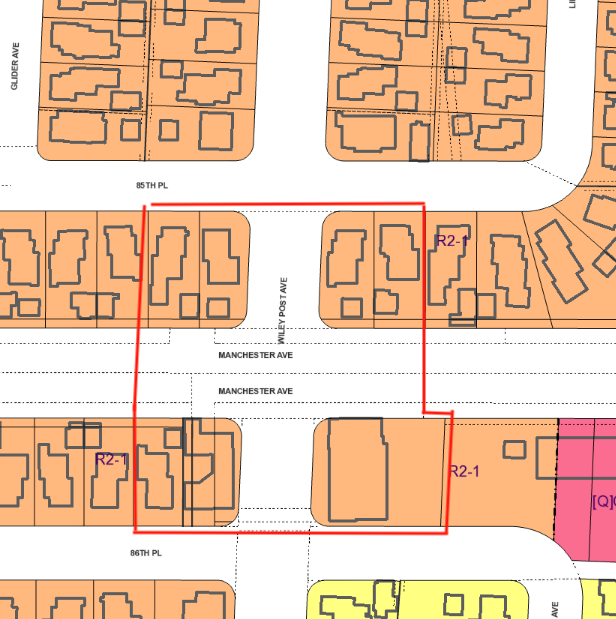
#1: Within WDPR 17, up-zone a very limited group of parcels. Specifically those at the intersection of Wiley Post and Manchester. Change from R2 to 4L to generate a small increment of additional housing near the Metro.
Pin-point up-zoing the parcels closest to the intersection with Manchester (an arterial) places a slight increase in housing density at an easy exit out of the neighborhood. Soft impact on the R2 area, and every extra housing unit near the Metro is a win for the community.
Zimas Map, indicating specific parcels for up-zoning:
Planning Definitions – Westside Community Plan Updates GPLU (2023)
General Plan Land Use (GPLU) – the basic character and functionality of a specific area, as defined by the options for land use in the City of LA’s General Plan for Housing.
GPLU Designation “Community Center” – Community Centers are vibrant places of activity typically located along commercial corridors, in concentrated nodes, or adjacent to major transit hubs. The building form ranges from Low Rise to Mid Rise, and may extend to Moderate Rise in the Downtown Community Plan. The use range is broad and may include commercial, residential, institutional facilities, cultural and entertainment facilities, and neighborhood-serving uses. The residential density generally ranges from 1 unit per 800 square feet of lot area to 1 unit per 200 square feet of lot area; residential density may also be limited by floor area.
CPLU Designation “Low-Medium Residential” – Low Medium Residential areas provide multi-unit housing, ranging from duplexes to small scale apartments, generally near neighborhood-serving uses. The building form ranges from House Scale to Very Low Rise. The residential density generally ranges from 1 unit per 3,000 square feet of lot area to 1 unit per 1,000 square feet of lot area.
